空中マッピング
航空測量、エリアマッピング技術
プロのUAVベースのマッピングソリューションの需要が高まっている。Photocomasia は、その顧客に安全でテストされ、プロのUAVマッピングソリューションを提供し、正確な地理空間情報を提供し、ワークフロー測定システムの一部とすることができる。
Photocomasia による空中調査や土地面積マッピングは、すべての土地面積ターゲットの超高精細画像を提供するために私たちのリモート制御のUAVドローンとマルチローターミニヘリコプターの飛行能力を備えた非常に最新のソフトウェア開発を組み合わせる。
Our UAV devices provide superior payload capacity, prolonged endurance, stable flight patterns, and a high degree of safety features. The process is computer controlled to ensure precise GPS point location and exact line following to achieve precise and accurate mapping presentations with no missed sectors.
We offer a complete mobile mapping solution from a single provider, including software for the capture, full service post-processing, and superbly detailed DVD data presentation.
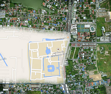
This technology is ideally suited to aerial mapping and surveying of;
- Agricultural developments
- Industrial estates’ planning and development.
- Measure progress rate of road, factory, or infrastructure developments.
- Land use planning and management.
- Real estate developments.
- Coastal erosion monitoring
- Natural disaster monitoring
- Urban planning and engineering
- Protection of the natural environment
- Civil protection
Please ask us for a quotation tailored to your exact schedule and requirements

Send mail to: Webmaster with questions or comments about this web site.
Copyright©Photocomasia 1999.
